

Baidu and University of Maryland introduce world’s first autonomous excavator that can perceive complex terrain
Researchers from Baidu Research Robotics and Auto-Driving Lab (RAL) and the University of Maryland, College Park (UMD) have developed a real-time mapping approach for autonomous navigation of excavators on complex terrains, named Terrain Traversability Mapping (TTM).
Using TTM, an autonomous excavator can navigate through unstructured outdoor environments consisting of deep pits, steep hills, rock piles and other complex terrain features.
This is the first complex terrain processing approach developed for heavy-duty excavation machines.
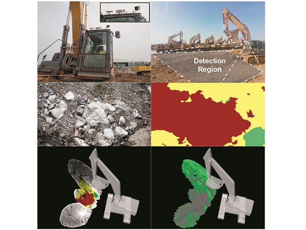
To enable autonomous excavators to handle complex terrains, the researchers developed a learning-based geometric method to extract terrain features from RGB images and 3D point clouds and incorporate them into a global map for planning and navigation.
 |
The method uses physical characteristics of the excavator, including maximum climbing degree and machine specifications, to determine the traversable area, adapt to changing environments and update the terrain information in real-time.
In addition, they have prepared a novel autonomous excavator terrain dataset, which consists of RGB images and LiDAR point clouds from construction sites with seven different categories based on navigability.
This integrates the mapping approach with planning and control modules to continuously improve the autonomous excavator navigation system.
Experiments showed that while using TTM, an excavator can navigate through unstructured environments with a much higher success rate compared to existing planning schemes.
Earlier in the year, Baidu RAL and UMD co-developed an autonomous excavator system that can perform material loading tasks for 24 hours without any human intervention, while offering performance nearly equivalent to that of an experienced human operator.